
www.magazine-industry-usa.com
17
'26
Written on Modified on
Compact Hybrid Airborne Mapping System Introduced
Leica Geosystems presents the Leica MultiMapper, a lightweight imaging and LiDAR platform designed for flexible deployment on helicopters and light fixed-wing aircraft.
leica-geosystems.com
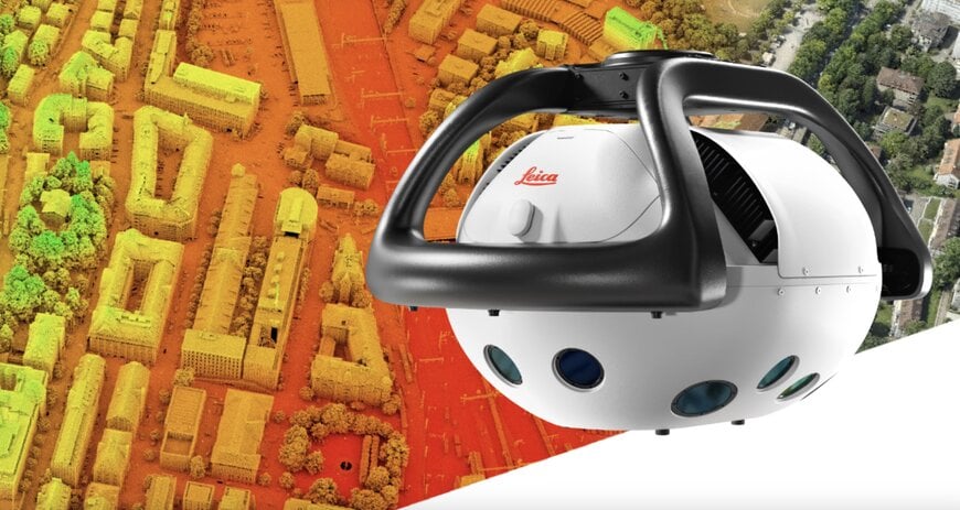
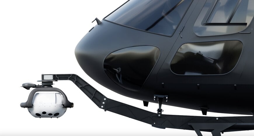
Leica Geosystems, part of Hexagon, has introduced the Leica MultiMapper, a compact hybrid airborne system combining multi-view imaging and high-density LiDAR in a single platform. Designed for installation on helicopters of various sizes and light fixed-wing aircraft, the system targets efficient airborne mapping across urban modelling, corridor mapping, infrastructure inspection, and post-event assessment applications.
Lightweight Design for Rapid Deployment
With a weight below 25 kg, the MultiMapper is engineered for simplified handling, transport, and installation. The reduced mass enables compatibility with a broad range of aircraft, including smaller helicopters and light fixed-wing platforms, expanding operational flexibility.
The system supports pilot-only operations, reducing mission complexity and crew requirements. Its compact configuration allows rapid mobilisation, enabling deployment, data acquisition, and demobilisation within a single operational day. This capability is particularly relevant for time-sensitive missions and mapping tasks in remote or difficult-to-access regions.
Integrated Imaging and LiDAR Acquisition
The MultiMapper integrates a multi-view camera system—capturing both nadir and oblique imagery—with a high-density LiDAR sensor. This hybrid configuration allows simultaneous acquisition of photogrammetric and laser scanning data.
Combining imagery and LiDAR in a single flight improves efficiency compared with sequential data collection approaches. The LiDAR component provides precise elevation and structural information, while multi-view imagery supports textured 3D city models, façade reconstruction, and visual inspection tasks.
Such hybrid airborne mapping systems are increasingly used for corridor mapping of roads and railways, urban digital twins, infrastructure monitoring, and rapid assessment following natural disasters or other events.
In-Flight Control and End-to-End Workflow Integration
The system is supported by Leica Geosystems’ workflow suite, including the Leica AirPro FIELD application. The tablet-based interface enables in-flight sensor control, mission parameter management, and flight status review.
Real-time monitoring of mission settings and flight parameters supports data quality assurance during acquisition. Integrated workflows aim to streamline the transition from airborne capture to data processing and delivery, reducing turnaround times for mapping projects.
By combining compact hardware design, hybrid data acquisition, and integrated mission control software, the Leica MultiMapper provides a flexible solution for high-performance airborne mapping across diverse operational scenarios.
www.leica-geosystems.com