Point One Delivers the First Highly Accurate and Easy-to-Use Precision Platform for Surveyors and Surveying Tool Manufacturers
Centimeter-accurate navigation works on most commonly used survey devices with intelligent assignment of local datums.

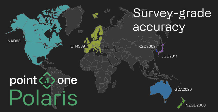
Point One Navigation a precision localization and navigation leader officially launched support for GIS product creators, surveyors, and construction professionals on the Polaris RTK Network. Polaris provides cm-accurate positioning at scale across the United States, Europe, Great Britain, Australia, New Zealand, and South Korea and is easily integrated into any dual-band GNSS receiver with RTK support.
Historically, achieving precision for the survey use case has required either setting up a base station at every location resulting in countless hours of lost time and productivity or integrating with legacy RTK networks. For the surveyor, these legacy networks force the user to plan for every job in advance, with specific connection instructions for each specific location.
For product creators, integration with legacy networks is difficult or impossible. These networks don’t contain critical security features like provisioning or management of device credentials. And the APIs for these networks are often complicated and poorly managed, with a slew of endpoints for developers to parse through. Because of these obstacles, product creators in the survey space generally just allow the user to pick their network. Supporting a myriad of legacy networks each with its own degree of accuracy creates untold numbers of support tickets, explanation requests, and lost time for valuable sales and distribution partners.
To solve this, Point One is releasing automatic assignment of datums and base stations. Users need only connect to a single mount point one time, and their devices consistently reference the closest base stations and the appropriate local datum – every time.
This eliminates the hassle of setting up, configuring, and connecting the most common survey devices. At launch, Point One is officially supporting all commonly used survey devices (full list below).
By integrating with Point One Navigation’s GraphQL API, product creators can provision, manage, and observe devices in real time through a single API endpoint. With this new release, product creators can deliver a complete solution that gives customers cm-accurate location with zero setup one that “just works” right out of the box. This allows companies to differentiate their products with unparalleled ease of use and create new recurring revenue streams for their devices.
“I can create accounts on the spot,” said Liav Muler, CEO of Civ Robotics. “With our previous vendor, I would have to do a PO and then it would take like 48 hours before the account would be activated.”
Whether you have a fleet of customers or want to connect a single device, here’s what you can expect with Point One’s Polaris for Survey:
- Survey-grade precision (cm-accurate) across the United States, European Union, United Kingdom, Australia, and Korea (and growing)
- Single-setup connection of RTK-compatible and dual-band receiver survey devices to Polaris in minutes
- Intelligent assignment of devices to the closest mount point and results in the relevant datum for your continent/country
- Support and automatic assignment of either ITRF2014 or local datums (including NAD83, ETRS89, NZGD2000, GDA2020, JGD2011, and KGD2002)
- Integration of survey devices in an afternoon through the Polaris GraphQL API
- Ability to manage, observe, and troubleshoot devices remotely at scale
- A fully managed network built entirely on industry-leading Septentrio receivers, with 99.99% uptime
- One transparent monthly or yearly price $150/month or $1,500/year
- Significant pricing incentives for large fleets
“Point One creates this de-risked environment,” says Larry Fox, CEO of Bad Elf, LLC. “As long as you have an active subscription, you only have to press a button and you get corrections. Done.”
In addition to the launch, Point One has pre-certified and tested the most popular devices, with more to come. They created easy-to-follow setup videos to guide users for the following devices:
- Bad Elf - Flex and Flex Mini
- Carlson – BRx7
- DJI drone - Mavic 3e
- Emlid - RS2+
- Eos Arrow GNSS - Gold
- Novatel - OEM6, OEM7, SPAN, CPT7
- Septentrio - Mosaic X5 (part of dev kit)
- Sparkfun - RTK Facet
- Trimble - R12, R11
- Quectel + ST - Standard Dev Kit
Learn more about the Polaris Launch.
Interested in trying Polaris? Try it free today.
www.pointonenav.com

